Please see ‘Related Articles’ link below after reviewing these pages.
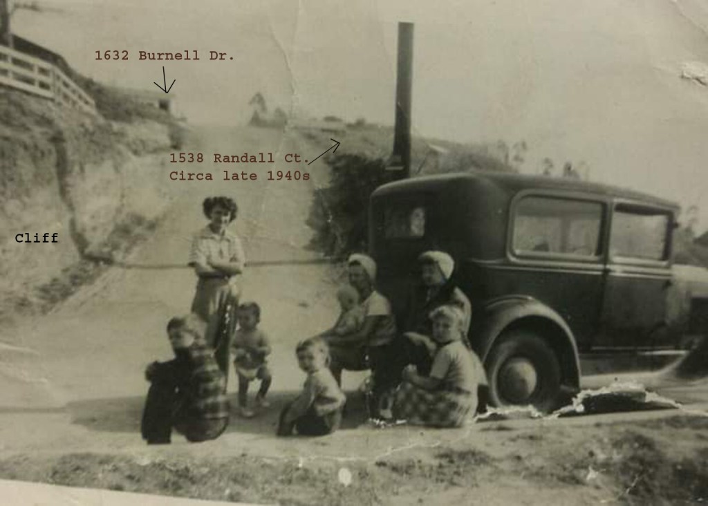
Year, late 1940s: Randall Court intersection at Killarney Ave. from Aileen Bartholomew (standing) to horizon (1538 Randall Ct. on the right); 1632 Burnell Drive in the background, built in 1947. Note: In the late 1940s, Northerly properties (left side) in the field of view do not access Randall Ct. (ie. cliff).
Latest from the Blog
1538 Randall Ct
1538 Randall Court, Los Angeles, CA, 90065 1538 Randall Court Parcel Plans (Case No. DIR-2008-2262-SPP, ENV-2008-2263-CE, Permit No. 08010-10000-01335): 1538 Randall Court LA County Assessors Map (APN 5464-030-027): 1538 Randall Court PS-456 Contour Map (1948 Easement Deed [Lot 28/] 40 is the easterly triangular lot portion of 1538 Randall Court, APN 5464-030-027): Based upon: April…
1538 Randall Court, Los Angeles, CA, 90065
1538 Randall Court, Los Angeles, CA, 90065
Click here to watch: VIDEO | 0:55
LA City Council Members Racist Rant on Redistricting
Definition: The process of drawing electoral district boundaries.
In October 2022, an anonymous Reddit account posted several shocking audio recordings. The recordings seem to contain the voices of Council President Nury Martinez (Resigned October 2022), Councilmembers Kevin de León (Council District 14, Formerly Jose Huizar’s) and Gil Cedillo (Council District 1), and LA Labor Federation President Ron Herrera discussing a wide range of topics of great public interest and being incredibly racist while doing so. Cedillo, Herrera, Martinez, and de León did not respond to requests for comment. “F**k that guy… he’s with the Blacks.” Martinez says of the adopted Black son of Councilmember Mike Bonin: “parece ch****ito” (“looks like a little monkey”). “This kid needs a beatdown. Let me take him around the corner, I’ll bring him right back.” Martinez further jokes about wanting to beat the adopted son of Bonin. “25 Blacks are shouting.” Herrera stated “I get what we have to do, right? Just massage to create the districts that benefit you all…I mean, we’re like the little Latino caucus of our, you know, our own…And, we have to find, you know, new folks to bring in.”


José Huizar Real Estate RICO Guilty Plea Court Document
George Esparza Real Estate RICO Guilty Plea Court Document
Get new content delivered directly to your inbox.

City of Los Angeles Zoning Information and Map Access System (ZIMAS) Tract Map, observed 2007 to Present:
Assessor’s Parcel Number 5464030016 – Ingress / Egress Address: 1532 Randall Court (01532) or 1535 Killarney Avenue (01535)
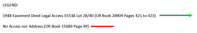
Assessor’s Parcel Number 5464030027 – Ingress / Egress Address: 1538 Randall Court (01538) in parcel easterly lot 28/40 plot division triangular portion (No access to Killarney Avenue due to southerly aerial easement)


Additional 1538 Randall Court Blog Images:
Summary of Blog Images 1948 to Present:
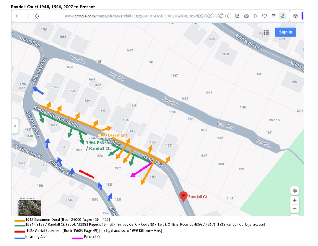
In 1948, this lot APN 5464030027 abutted a dirt easement, and no houses on either side were built, except 1632 Burnell Dr. The 1948 easement deed states that anytime within 15 years the easement can be used for public use.
In 1963, one of the lot owners that has easement rights (Lot 40) lot line adjusted one of this five lots lot between Lot 28 and Lot 40 giving both of these lots easement rights. For legal or budgetary reasons the City of Los Angeles would not pave the easement. According to City codes a buildable lot must abut a private or public street. Burnell Dr. was to be phased out. The 1964 Private Street PS-456 was ONLY created to benefit all abutting lots 15## to 1454 Randall Ct. on both sides of the dirt easement, including 1538 Randall Ct., by paving it so the houses can be built. Thus, all lots including the five southerly parcels that abut the 1948 dirt easement, improved to paved PS-456, are legal building sites that can use PS-456 for access.
Then, per the PS-456 survey map by its 10-year statute of limitations to contest it (effective 1974) current use Randall Ct. is a through public street consistent with the ‘public use’ stipulation in the 1948 easement deed. Note: Private streets are dead end and/or gated.
The compensation in financial damages to Gary Roy by the City of Los Angeles for violations of the Unruh Act, Title VI & VIII of the Fair Housing Act and the Racketeer Influenced and Corrupt Organization Act, which comprises $2,010,889.67 base damages (LASC Cases BC422522/BC413819-2012) plus interest to 2024 and 4 times penalty is a total of $22,949,211.65, as at Dec. 2023.
Also a City of Los Angeles violation of The Rome Statute of The International Criminal Court, Part 2. Jurisdiction, Admissibility and Applicable Law, Article 7(a), (d), (h), (j), and (k).
